| North
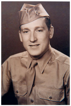
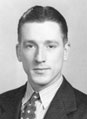
High School Wall of Honor Fred Arthur Reeck Class of June, 1936 |
 |
|||||||||||||||||||||||||||||||||||||||||||||||||||||||||||||||||||||||||||||||||||||||||||
| Research done by Claradell Shedd, Class of 1953. | ||||||||||||||||||||||||||||||||||||||||||||||||||||||||||||||||||||||||||||||||||||||||||||
| Fred graduated from the North High class of June, 1936. He was drafted into the US Army in Des Moines, IA. At the time of his induction, his next of kin were Mr. and Mrs. John George Reeck, 1706 West Seventh, Des Moines, IA. His service number was 37682645. | ||||||||||||||||||||||||||||||||||||||||||||||||||||||||||||||||||||||||||||||||||||||||||||
|
||||||||||||||||||||||||||||||||||||||||||||||||||||||||||||||||||||||||||||||||||||||||||||
| **64th Engineer
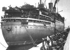
Topographic Battalion In February 1940, a topographic company was created from a nucleus of officers and enlisted men from the 29th Engineer Topographic Battalion and the 4th Combat Engineers, and designated as the 64th Engineer Topo Company. The summer of 1940 was spent producing mapping requirements for the 3rd Army maneuvers in Louisiana. The following summer of 1941 found the 64th Company doing the same thing, this time for the 2nd Army maneuvers. December of 1941 was the Japanese attack on Pearl Harbor, and by February of 1942 the unit was entrained to Fort Ord, California in preparation for overseas movement. On June 22, 1942, the 64th Engineer Topographic Company sailed from San Francisco on the USS President Johnson, bound for Hawaii. At Scofield Barracks, their main task was mapping work for the extension of Pearl Harbor's defense installations. In September of that year, a new unit, the 651st Engineer Topographic Battalion was created at Fort Maxey, Texas around a cadre from the 30th Engineer Topographic Battalion at Fort Belvoir, Virginia. During the first year of the 651st basic and technical training they perfected the military art of mapping, compiling, and printing maps. So in September 1943, the 651st went to the Mojave Desert in California, with the mission of preparation of maps and battle overlays for the troops undergoing mock battles under field conditions. That five-month tour was followed by the movement to the Port of Embarkation in Seattle, Washington. The third member of the 64th Engineer Topographic Battalion, the 1633rd Photomapping platoon, was activated at Portland, Oregon, on November 5, 1943 and was attached to the 64th Engineer Topographic Battalion. The 29th Engineer Topographic Battalion at Portland, Oregon, supplied the personnel. Their nine-month training period was devoted to Multiplex manuscripts of the Harbor Defense Systems for the State of Washington. The platoon sailed from Seattle on August 13, 1944 and arrived at Scofield Barracks 8 days later, and was assigned to the 64th Engineer Topographic Battalion. Within a month, the platoon was producing manuscripts of the Bonin Islands, and experimenting in producing scale clay models from photo coverage of Iwo Jima. When the 651st Engineer Topographic Battalion arrived in Hawaii in April 1944. It was amalgamated with the 64th Engineer Topographic Company, and along with the 1633rd Photomapping platoon, the new unit was designated the 64th Engineer Topographic Battalion. The immediate technical work of the 64th Engineer Topographic Battalion concerned mapping for the joint Army-Navy-Marine attack on the Mariana and Caroline Island chains. Some 4,500,000 copies of operational maps, terrain studies and nautical charts were required for the mapping requirements of Tlnian, Guam and Saipan. Then In June 1944, work was begun on mapping of the Islands of Yap, Ulithi and Palau. The battalion commander was assigned to the staff of the Central Pacific Base Command, and took over the command of all topographic facilities In the Command. Two top priority jobs were undertaken: a 180,000 copy project on the Philippine Islands, and coverage of the Bonin (Iwo) Islands. The next project dealt with the coming invasion of Okinawa, for which 1136 separate drawings were prepared in Photomapping for the eventual production of about 4,000,000 maps. Having completed those projects, the 64th Engineer Topographic Battalion boarded the USS Rockingham, and three weeks later arrived at Fleet Admiral Nimltz's Advance Headquarters on Guam. On August 1, 1944, sixty enlisted men and three officers of the 64th Engineer Topographic Battalion formed the Provisional Engineer Topographic Mapping Detachment and were attached to the XXIV Army Corps. On September 15 the Detachment left Pearl Harbor on the USS President Hayes for an unknown destination. After touching at Eniwetok, on October 3, they reached Manus Island, the jumping-off place for the invasion of Leyte Island in the Philippines. When the mapping of Leyte was completed, XXIV Corps included the Detachment in the last major operation of the war, the Okinawa campaign, where they went ashore on April 20,1945. By July, mapping work was completed, and eleven months after they left Hawaii, the Detachment rejoined the 64th Engineer Topographic Battalion on Guam on 13 August 1945. While the Detachment had been away, the 64th Engineer Topographic Battalion worked to establish its base of operations. By April 15, 1944, the battalion's technical equipment was housed in Quonset huts so that Operations, Photomapping, Reproduction and Map Distribution could continue to operate at the largest naval headquarters outside of the United States. A five sheet, 100,000 copy project on the Japanese held sectors of Okinawa was finished in 48 hours for delivery to the 10th Army's artillery. Additional assignments from the Army Air Force and Coast Guard, plus two newly initiated projects on Tanega and Koshiki Shima, amounted to 235 separate drawings and 3,627,000 copies during April. May saw the first of the innovative Photo Coverage Surveys, which assumed top priority by June 1 and continued until the Japanese surrender after the atomic bombing of Hiroshima and Nagasaki in August 1945. In October 1945, the 64th Engineer Topographic Battalion was made part of the Army of Occupation of Japan and was based in the third, fourth, fifth and sixth floors of the Isetan department store in the Shinjuku District of western Tokyo, Japan, where they continued the mapping and photo coverage survey programs. |
||||||||||||||||||||||||||||||||||||||||||||||||||||||||||||||||||||||||||||||||||||||||||||
| 64th Engineer
Topographic Battalion, Army Source: "World War II Order of Battle", Shelby L. Stanton, 1984 Formed: 5 Apr 44 Schofield Barracks, Hawaii (64th Engineer Co) Inactivated: (Active through 1946) Locations: Hawaii 5 Apr 44; Guam 1 Apr 45 |
||||||||||||||||||||||||||||||||||||||||||||||||||||||||||||||||||||||||||||||||||||||||||||
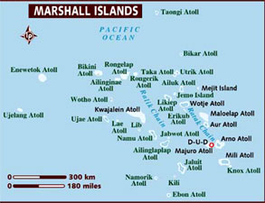
| ***Marshall
Islands In the months before the attack on Pearl Harbor, Kwajalein Atoll was the administrative center of the Japanese 6th Fleet Forces Service, whose task was the defense of the Marshall Islands. In World War II, the United States, during the Gilbert and Marshall Islands campaign, invaded and occupied the islands in 1944, destroying or isolating the Japanese garrisons. The archipelago was added to the U.S. Trust Territory of the Pacific Islands, along with several other island groups in the South Sea. The battle in the Marshall Islands caused irreparable damage, especially on Japanese bases. During the American bombing, the islands' population suffered from lack of food and various injuries. U.S. attacks started in mid-1943, and caused half the Japanese garrison of 5,100 people in the atoll Mili to die from hunger by August 1945.[12] In just one month in 1944, Americans captured Kwajalein Atoll, Majuro and Enewetak, and in the next two months the rest of the Marshall Islands except Wotje, Mili, Maloelap and Jaluit. |
||||||||||||||||||||||||||||||||||||||||||||||||||||||||||||||||||||||||||||||||||||||||||||
|
||||||||||||||||||||||||||||||||||||||||||||||||||||||||||||||||||||||||||||||||||||||||||||
|
||||||||||||||||||||||||||||||||||||||||||||||||||||||||||||||||||||||||||||||||||||||||||||
|
||||||||||||||||||||||||||||||||||||||||||||||||||||||||||||||||||||||||||||||||||||||||||||
|
||||||||||||||||||||||||||||||||||||||||||||||||||||||||||||||||||||||||||||||||||||||||||||
| 09/05/11: Died 09/02/11. | ||||||||||||||||||||||||||||||||||||||||||||||||||||||||||||||||||||||||||||||||||||||||||||
| Music: "Wind Beneath My Wings" | ||||||||||||||||||||||||||||||||||||||||||||||||||||||||||||||||||||||||||||||||||||||||||||
| Home
|
Back/allyears |
WWI |
WWII |
Korea |
Vietnam |
Afghanistan/Iraq |
Lyrics
|
Refs/Awards |
Contact ©2023-csheddgraphics All rights reserved. All images and content are © copyright of their respective copyright owners. |
||||||||||||||||||||||||||||||||||||||||||||||||||||||||||||||||||||||||||||||||||||||||||||